Antelope Valley is located in the northern part of Los Angeles County and the southeastern part of Kern County in Southern California, United States. The main cities in Antelope Valley are Palmdale and Lancaster, which are the largest cities in the California High Desert region.
What is Antelope Valley famous for?
Antelope Valley is famous for several reasons. The valley is known for its beautiful natural landscapes, including the Antelope Valley California Poppy Reserve, which is home to stunning wildflower displays in the spring. It is also known for its aerospace industry, with the Mojave Air and Space Port and Edwards Air Force Base located nearby. The valley is also home to the famous Tehachapi Pass Wind Farm, one of the largest wind farms in the world.
What cities are part of Antelope Valley?
The main cities in Antelope Valley are Palmdale and Lancaster, which are the largest cities in the California High Desert region. Other smaller towns and communities in the Antelope Valley include Lake Los Angeles, Quartz Hill, and Pearblossom.
What town is close to Antelope Valley?
One town that is close to Antelope Valley is Lancaster, California. It is one of the main cities in the Antelope Valley region and is located in the northern part of Los Angeles County. Another town near Antelope Valley is Palmdale, which is also in the Antelope Valley region. Both of these towns are part of the California High Desert region and are known for their natural beauty, including the Antelope Valley California Poppy Reserve, which is famous for its stunning wildflower displays in the spring.
Lockheed Martin is an aerospace and defense company that has a significant presence in Palmdale, California. At their Palmdale facility, they are involved in various activities, including the design, development, and production of advanced aircraft and technologies.
One of their notable projects is the Skunk Works division, which is responsible for many aerospace firsts, such as the United States' first jet fighter (P-80), the world's first stealth fighter (F-117), and the world's first 5th generation fighter (F-22). The Skunk Works team is currently working on a wide range of advanced technologies, including hypersonic systems and other cutting-edge innovations.
The company recently completed the construction of a high-tech manufacturing facility in Palmdale, which incorporates digital tools, robotics, artificial intelligence, and augmented reality to reduce the need for hard tooling and enhance the human experience. This facility is designed to support the United States and its allies with innovative solutions rapidly and affordably.
In summary, Lockheed Martin in Palmdale, CA, focuses on the development, production, and innovation of advanced aircraft and technologies, contributing to the advancement of the aerospace and defense industry.
How much does Lockheed Martin pay in Palmdale CA?
According to the information gathered from various sources, the average salary at Lockheed Martin in Palmdale, CA, ranges from $79,961 to $104,370 per year. The pay scale can vary based on factors such as position, experience, and education.
For example, an Aerospace Engineer at Lockheed Martin in Palmdale earns an average salary of $104,370 per year, while an Industrial Engineer earns an average of $79,961 per year.
It's important to note that these figures are based on the data accessed, and the actual salary may vary depending on the specific job and individual circumstances.
How many people work at Lockheed Palmdale?
According to the information gathered, Lockheed Martin's Palmdale facility employs over 4,000 people. This workforce includes engineers, technicians, and other professionals who work on various projects, such as the development and production of advanced aircraft and technologies.
The company has recently completed the construction of a high-tech manufacturing facility in Palmdale, which incorporates digital tools, robotics, artificial intelligence, and augmented reality to reduce the need for hard tooling and enhance the human experience. This facility is designed to support the United States and its allies with innovative solutions rapidly and affordably.
When did Lockheed move to Palmdale?
Lockheed Martin's presence in Palmdale, California, dates back to the 1980s when the company established its Advanced Development Projects facility, also known as the Skunk Works, in the area. The Skunk Works division is responsible for many aerospace firsts, such as the United States' first jet fighter (P-80), the world's first stealth fighter (F-117), and the world's first 5th generation fighter (F-22).
In recent years, Lockheed Martin has continued to expand its operations in Palmdale. In 2018, the company began construction on a high-tech manufacturing facility in the area, which was completed in 2021. This new facility incorporates digital tools, robotics, artificial intelligence, and augmented reality to reduce the need for hard tooling and enhance the human experience.
While Lockheed Martin has had a long-standing presence in Palmdale, the specific date of their initial move to the area is not readily available. However, it is clear that the company has been actively involved in the Palmdale community for several decades and continues to invest in the region.
One of the most famous movies filmed at Vasquez Rocks is "Star Trek IV: The Voyage Home" (1986). In this film, the rocks were used as the location for the planet Vulcan.
How long does it take to hike Vasquez Rocks?
It takes about 2 hours to hike Vasquez Rocks. The hike is approximately 3.4 miles long with an elevation gain of 310 feet. The trail is well-marked and offers stunning views of the unique rock formations surrounded by grassland, with the San Gabriel Mountains in the background.
Why is Vasquez Rocks famous?
Vasquez Rocks is a 932-acre park located in the Sierra Pelona Mountains in northern Los Angeles County, California. The site is famous for its unique rock formations, which were formed by rapid erosion during uplift about 25 million years ago. The park is named after the notorious bandit Tiburcio Vásquez, who used the area as a hideout in the 1870s.
Vasquez Rocks has been a popular filming location for numerous movies and TV shows, including Star Trek, Planet of the Dinosaurs, and The Flintstones. The unique and picturesque landscape has made it a favorite spot for filmmakers and photographers alike.
The history of the area includes the presence of the Shoshone and Tataviam peoples, as well as the Rancho period and the homesteading period. The Tataviam were particularly affected by the Spanish mission system, which led to the decline of their population.
The geology of the area is characterized by the Soledad Basin, which is cradled by the Sierra Pelona Mountains to the northwest and the San Gabriel Mountains to the east. The Vasquez Formation consists of alluvial sediments that eroded from these mountains and were deposited in alluvial fans on both sides of the Soledad Basin.
Can you go to Vasquez Rocks at night?
Yes, you can visit Vasquez Rocks at night. The park is open from sunrise to sunset, but you can also join ranger-led night hikes that are offered periodically. These hikes provide a unique opportunity to explore the park under the stars and learn about the nocturnal wildlife in the area.
Lake Los Angeles is a census-designated place (CDP) located in Los Angeles County, California. The name "Lake Los Angeles" can be traced back to the 1960s when a developer named M. Penn Phillips created a planned community in the area. The community was originally named "Palmdale Lake" due to its proximity to Palmdale and the presence of a man-made lake.
In 1967, another developer, Reseda, bought the land and renamed the community "Lake Los Angeles." The name change was likely an attempt to capitalize on the allure of the Los Angeles name and attract more residents to the area.
The lake, which was once a popular recreational spot for boating and fishing, was drained in 1981 due to the high cost of maintenance. Despite the absence of the lake, the name "Lake Los Angeles" has remained.
Is Lake Los Angeles unincorporated?
Lake Los Angeles is an unincorporated community in Los Angeles County, California. This means that it is not governed by a local municipal corporation and is instead directly administered by the county government. The community is located in the Antelope Valley, near the San Bernardino County line, and has a population of around 12,000 people. Despite its name, Lake Los Angeles is not actually near the city of Los Angeles, and it does not have a lake. The name was given to the area in the 1960s as part of a real estate development project.
What's the zip code for Lake Los Angeles?
There are two ZIP codes in Lake Los Angeles, California: 93535 and 93591. These ZIP codes serve the residents of the area, providing them with efficient mail delivery and other postal services.
Is there water in Lake Los Angeles?
Yes, there is water in Lake Los Angeles. Lake Los Angeles is an unincorporated community in Los Angeles County, California. The community was named after a man-made lake that was originally created in the 1960s as part of a real estate development project. However, the lake was drained in 1981 due to the high cost of maintenance. Despite the absence of the lake, the name "Lake Los Angeles" has remained.
It is worth noting that the community has a history of water issues, including a lack of access to clean drinking water in the past. However, efforts have been made to improve the water infrastructure and provide safe drinking water to residents.
Mojave, a city in California, is home to the Mojave Air and Space Port, which has a rich history in aviation and aerospace. The airport was initially established in 1935 and served the local mining industry. During World War II, the U.S. Marine Corps expanded the facility to train thousands of pilots, and it was later used by the Navy and Marines for various purposes.
There are several reasons for the high number of planes in Mojave:
• Storage: The Mojave Air and Space Port has a large, dry desert area that is ideal for storing aircraft. The low humidity and flat terrain make it a cost-effective location for airlines to park their planes temporarily or permanently.
• Aircraft recycling: Mojave is home to various aircraft recycling and dismantling companies, such as the Mojave Boneyard. These companies acquire retired aircraft and harvest their parts for resale or recycling, contributing to the high number of planes in the area.
• Aerospace research and development: The Mojave Air and Space Port is a hub for aerospace research and development, with companies like Stratolaunch and Virgin Galactic operating in the area. These companies test and develop new technologies, which can involve a large number of aircraft.
• Flight training: The area's history in military flight training continues to this day, with various organizations providing flight training services for both civilian and military pilots.
In summary, the high number of planes in Mojave can be attributed to its ideal storage conditions, aircraft recycling and dismantling companies, aerospace research and development, and flight training facilities.
Can you visit the airplane graveyard in Mojave?
Yes, you can visit the airplane graveyard in Mojave, also known as the Mojave Air and Space Port. The facility is open to the public, but tours are not offered. However, you can visit the Voyager Restaurant, which is located on the premises, and during official events, visitors are allowed to enter the airport property from the south on Airport Boulevard at the Highway 58 entrance.
While you can't get up close to the planes, you can still see them from a distance and take photographs. The best viewing spot is from South Bullard Avenue, which runs along the west side of the airport. Remember to be respectful of the facility's rules and not to enter restricted areas.
Who owns the Mojave Air and Space Port?
The Mojave Air and Space Port is owned by the East Kern Airport District (EKAD), a public agency created by the County of Kern in 1972. Its primary purpose is to manage and develop the airport for public use. The airport is located in Mojave, California, and serves as a hub for various aerospace activities, including flight testing, research, and development.
What companies are at the Mojave Space Port?
The Mojave Air and Space Port is home to numerous companies in the aerospace and aviation industries. Some of the notable companies and organizations based at the Mojave Space Port include:
• Virgin Galactic: A British spaceflight company that aims to provide suborbital spaceflights for space tourism and scientific research.
• The Spaceship Company: A subsidiary of Virgin Galactic, this company is responsible for manufacturing and assembling the SpaceShipTwo and WhiteKnightTwo spacecraft.
• Masten Space Systems: A company that develops and tests reusable rocket technology for lunar and planetary missions.
• Scaled Composites: An aerospace company that designs and builds experimental aircraft, including the SpaceShipOne, which won the Ansari X Prize in 2004.
• National Test Pilot School: A professional training school for test pilots and flight test engineers.
• Orbital Sciences Corporation: A company that provides launch services and designs, builds, and tests space systems for commercial, military, and government customers.
• XCOR Aerospace: A company that develops and builds reusable rocket engines and launch vehicles.
• Firestar Technologies: A company that specializes in advanced propulsion systems and technologies for space exploration.
• Interorbital Systems: A company that develops and builds low-cost, modular satellite launch vehicles.
• Stratolaunch Systems: A company that develops and operates air-launch-to-orbit systems for satellite deployment.
These companies and organizations contribute to the diverse aerospace and aviation activities at the Mojave Air and Space Port, making it a hub for innovation and development in the industry.
In the Tehachapi Pass, there are approximately 4,700 wind turbines generating clean and renewable energy. This wind farm is one of the largest in the world and plays a significant role in California's renewable energy goals.
Who owns Tehachapi Pass wind farm?
The Tehachapi Pass wind farm is a large-scale wind farm located in the Tehachapi Pass of the Tehachapi Mountains in California, United States. It is one of the first large-scale wind farms in the country, with around 4,700 wind turbines generating clean and renewable energy.
The ownership of the Tehachapi Pass wind farm is divided among several companies and organizations. Some of the major players in the development and operation of the wind farm include:
Southern California Edison (SCE): A major investor-owned electric utility in Southern California, which has played a significant role in the development and expansion of the wind farm.
NextEra Energy Resources: A subsidiary of NextEra Energy, Inc., it is the world's largest generator of renewable energy from wind and sun. The company owns and operates several wind projects in the Tehachapi Pass area.
Terra-Gen Power: A renewable energy company that develops, constructs, and operates utility-scale wind, solar, and geothermal projects. Terra-Gen owns and operates wind projects in the Tehachapi Pass.
Iberdrola Renewables: A subsidiary of the Spanish utility company Iberdrola, it is one of the largest wind energy developers in the United States. The company owns and operates several wind projects in the Tehachapi Pass.
These companies, along with other smaller investors and developers, contribute to the ownership and operation of the Tehachapi Pass wind farm. The wind farm plays a significant role in California's renewable energy goals and continues to expand as more companies invest in clean energy.
What city in California has the most wind turbines?
The city in California with the most wind turbines is Tehachapi, located in the Tehachapi Pass of the Tehachapi Mountains in Kern County. This area is known for its abundant wind resources, making it an ideal location for wind energy generation. The Tehachapi Pass wind farm is one of the largest in the world, with approximately 4,700 wind turbines generating clean and renewable energy.
How many windmills are in Kern County?
In Kern County, California, there are approximately 4,700 wind turbines generating clean and renewable energy. This wind farm is one of the largest in the world and plays a significant role in California's renewable energy goals.
How long will the Antelope Valley Superbloom last?
The Antelope Valley California Poppy Reserve typically experiences its superbloom from mid-March to mid-April. However, the exact duration can vary depending on weather conditions, such as temperature and rainfall. It is important to keep an eye on the bloom reports from local parks and nature reserves to get the most accurate information on the current bloom status.
Where is the best place to see the California poppies?
The best place to see the California poppies is the Antelope Valley California Poppy Reserve, located in Lancaster, California. This state reserve is known for its vast fields of vibrant orange poppies, especially during the blooming season from mid-March to mid-April. The reserve offers several trails for visitors to explore and enjoy the beautiful scenery.
However, it's worth noting that other locations in Southern California also have impressive poppy displays. For example, the Lake Elsinore area and the hills near Agua Dulce are known for their colorful poppy blooms. These locations may offer alternative spots to view the stunning wildflowers.
Are the California poppies blooming now?
Yes, the California poppies are blooming now in the Antelope Valley California Poppy Reserve. The bloom typically occurs from mid-March to mid-April, and this year, the bloom is expected to be particularly vibrant due to the recent rains. However, the exact timing and duration of the bloom can vary depending on weather conditions. It is always a good idea to check for recent updates and reports on the bloom status before planning a visit to the reserve.
What is the best time to visit Antelope Valley?
The best time to visit Antelope Valley is during the spring season, from mid-February to late May, when the Antelope Valley California Poppy Reserve is in bloom. The peak bloom time for the reserve's signature golden poppies is usually in late March or early April, but this can vary from year to year depending on weather conditions. Visiting during this time will give you the best chance to see the vibrant orange and yellow fields of poppies in full bloom.
What area is considered the high desert in Southern California?
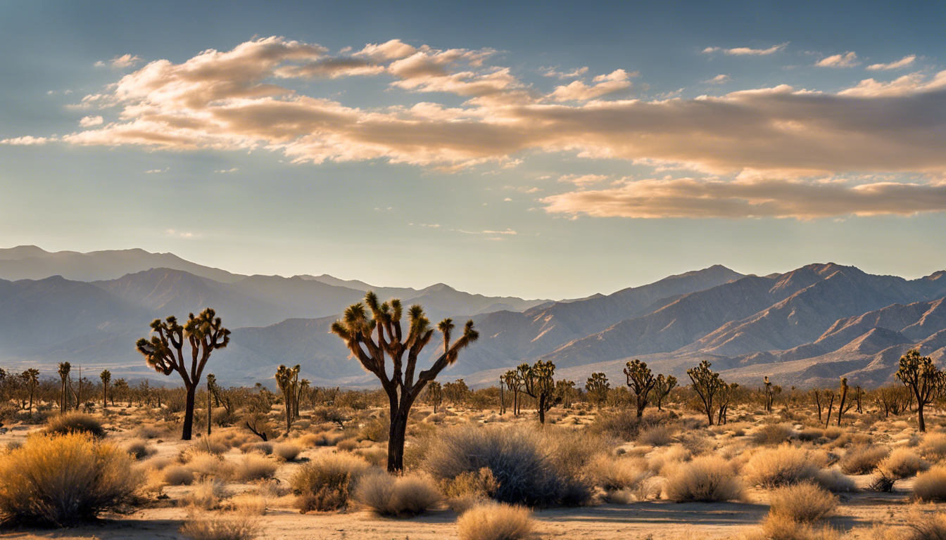
The high desert in Southern California is generally considered to be the area that encompasses the Mojave Desert, which includes parts of San Bernardino County, Los Angeles County, and Kern County. This region is known for its higher elevation and unique climate, which is distinct from the low desert areas like the Colorado Desert and the lower regions of the Sonoran Desert. The high desert typically includes cities such as Lancaster, Palmdale, Victorville, Hesperia, and Apple Valley. The region is characterized by its rugged terrain, Joshua trees, and unique wildlife.
Is Riverside the High Desert?
Riverside is not considered part of the High Desert in Southern California. The High Desert region typically includes the Mojave Desert Basin and the Antelope Valley, which are located in San Bernardino and Los Angeles counties. Riverside is part of the Inland Empire, which is adjacent to the High Desert but not within it.
Is Bakersfield considered high desert?
Bakersfield, California is not typically considered part of the high desert region. The high desert in California is generally considered to be the area that encompasses the Mojave Desert, which includes parts of San Bernardino County, Los Angeles County, and Kern County. Bakersfield is located in Kern County, but it is situated in the southern end of the San Joaquin Valley, not in the high desert region.
Is Palmdale considered high desert?
Palmdale is considered to be part of the High Desert region in Southern California. This region encompasses parts of San Bernardino, Los Angeles, and Kern counties, and is known for its unique climate and geography. Palmdale is located in the Antelope Valley, which is part of the Mojave Desert Basin. The High Desert region is characterized by its rugged terrain, Joshua trees, and unique wildlife. Palmdale's elevation and location within the Mojave Desert Basin make it a part of the High Desert.
Edwards Air Force Base is famous for its rich history in flight testing and research. It is known as the "Center of the Aerospace Testing Universe" due to its role in testing and evaluating almost every aircraft since World War II. The base has been host to extensive aircraft testing and has achieved many milestones in flight, including breaking the sound barrier and testing the F-22 Raptor.
The base is also known for its association with the X-15 program, which explored hypersonic and exoatmospheric flight. Additionally, Edwards Air Force Base has contributed to the development of various advanced military aircraft, such as the B-58 Hustler and the F-15.
Edwards Air Force Base has a unique natural environment that is conducive to flight testing, with its vast dry lakebeds serving as emergency landing sites and test areas. The base is named after Capt. Glen Edwards, who was a test pilot and lost his life in a crash. His legacy is honored at the base, which continues to push the boundaries of aviation and aerospace technology.
What is the closest city to Edwards Air Force Base?
The closest city to Edwards Air Force Base is Rosamond, California, located about 13 miles (21 km) to the south. Another nearby city is Lancaster, California, which is about 20 miles (32 km) to the west of the base. Both cities offer a variety of amenities and accommodations for visitors to the area.
What desert is Edwards Air Force Base in?
Edwards Air Force Base is located in the Mojave Desert of Southern California. The base is situated in Kern County, near the cities of Lancaster and Palmdale, and is approximately 100 miles northeast of Los Angeles. The Mojave Desert is known for its hot and dry climate, making it an ideal location for the base's flight testing and research activities.
What was filmed on Edwards AFB?
Edwards Air Force Base has been a popular filming location for various movies and TV shows. Some of the productions filmed at Edwards Air Force Base include:
The Right Stuff (1983) - A historical drama film about the U.S. space program and the test pilots involved in aeronautical research at Edwards Air Force Base.
Armageddon (1998) - A science fiction film that follows a group of oil drillers sent by NASA to stop an asteroid from colliding with Earth. The crew was allowed to shoot at the historic launch pad at Edwards Air Force Base.
Race to Space (2001) - A family drama film about a young boy who dreams of becoming an astronaut. The movie was loosely based on the early U.S. space program, Project Mercury, which included several flights made with monkeys and chimps.
Space Cowboys (2000) - A comedy-drama film about four aging "ex-test pilots" who are sent into space to repair an old Soviet satellite. The film features scenes shot at Edwards Air Force Base.
Captain Marvel (2019) - A superhero film that follows Carol Danvers, an Air Force pilot, as she becomes one of the universe's most powerful heroes. The film features scenes shot at Edwards Air Force Base, and the base's Hangar 1600 and the ramp just outside of it can be seen in the trailer.
These are just a few examples of the movies and TV shows that have been filmed at Edwards Air Force Base. The base's unique desert environment and facilities have made it an attractive location for various productions.
The elevation of Pearblossom, California, is approximately 3,150 feet (960 meters) above sea level. This small unincorporated community is located in the Antelope Valley of the Mojave Desert, in northern Los Angeles County, California.
What city is Pearblossom Highway in?
Pearblossom Highway begins in the city of Palmdale, California. It is a major road that runs through several small towns in the Antelope Valley, like Littlerock, Pearblossom and Llano.
What are the best things to do in Pearblossom, CA?
One of the best things to do in Pearblossom, CA is to visit the Devil's Punchbowl Natural Area. This unique geological formation offers a 1-mile loop trail that takes you down into a deep canyon where you can explore and climb to your heart's content. Another great place to visit is Charlie Brown Farms in neighboring Littlerock, a roadside shop that sells everything from snacks and trinkets to dinosaurs and toys. You can easily spend an hour browsing their 1,000+ items spread across three buildings and two patios. If you're looking for outdoor activities, you can also explore the nearby San Gabriel Mountains, which offer stunning views and various hiking trails.